


The battle over Khartoum’s bridges
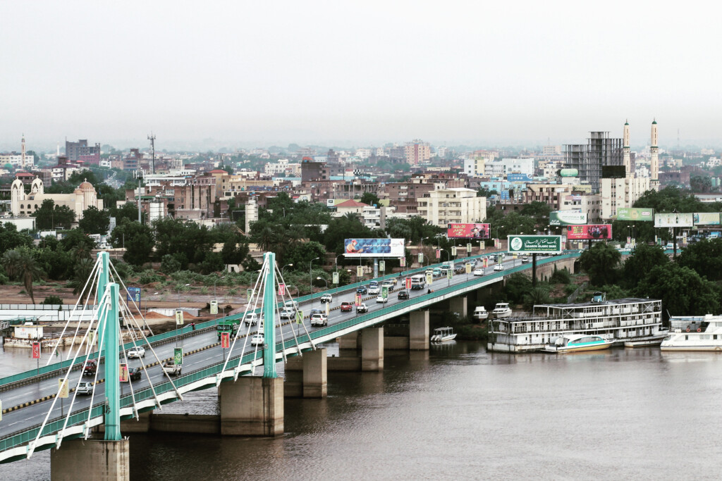
El Mek Nimr Bridge, Khartoum (File Photo: Wikimedia Commons)
With the destruction of the Shambat Bridge, Khartoum’s bridges find themselves on top of the priority list of the warring parties. In this article, Radio Dabanga looks at the role of bridges in the development of Sudan’s battles.
Bridges are important strategic locations in battle. They allow for communication or supply lines over water, and there are few alternative routes. Controlling a bridge can mean the difference between life and death or victory and defeat.
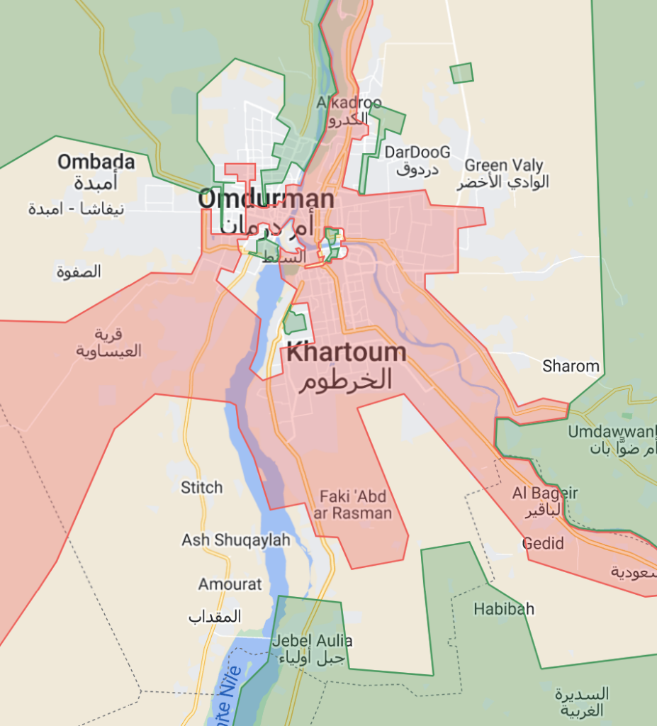
Khartoum is home to 10 bridges across the twin rivers in the state: the Blue Nile, the White Nile, and the main River Nile in which they merge east of Tuti island. These bridges connect the cities of Khartoum, Omdurman, and Khartoum North (Khartoum Bahri). They are not only important crossings for those within the city but also for the wider region.
Up north, there is no other bridge over the Nile until you reach Shendi in River Nile state and down south, the first opportunity to cross the White Nile is in Kosti, White Nile state, more than 300km south of Khartoum. Both are hours away from Sudan’s capital, even if an unhindered drive would be possible, which it is not in wartime.
Khartoum has been a key battleground since war broke out between the Sudan Armed Forces (SAF) and the paramilitary Rapid Support Forces* (RSF) in mid-April, and both parties control parts of the cities.
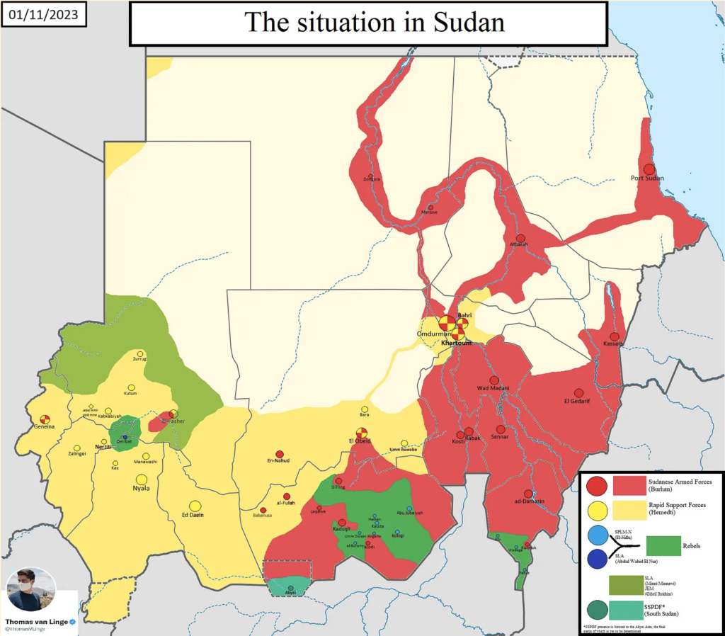
As this map from the situation around October 24 shows, the RSF (red) are in control of large parts of Khartoum and Khartoum North, but the army (green) is holding out in some key positions, especially in Omdurman. This particular map is now slightly outdated, but the areas of control are not dissimilar.
On Saturday, the Shambat Bridge that connects Omdurman and Khartoum North across the Nile was destroyed in a blast. Both sides exchanged accusations and have denied being behind the destruction.
It is clear, however, that the bridge was of high strategic importance to the RSF.
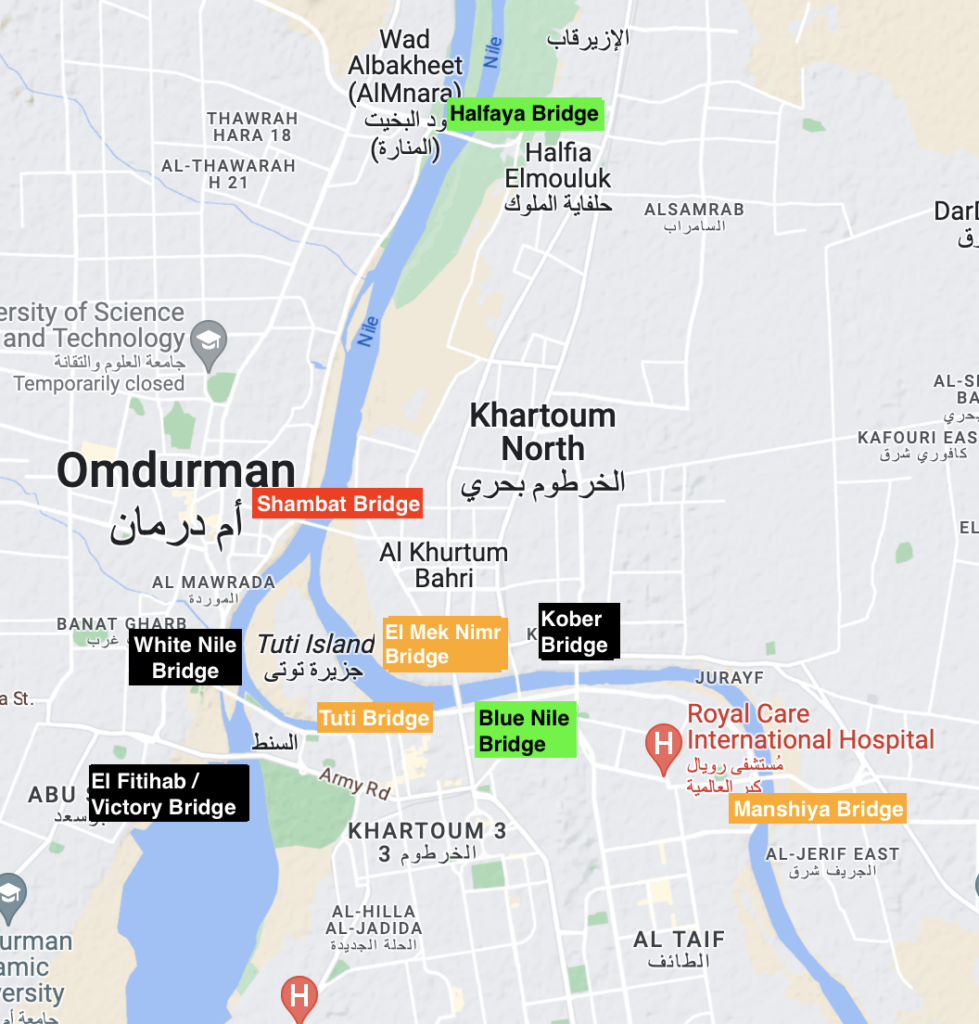
As can be seen on the maps below, the RSF do control other bridges in Khartoum. Across the Blue Nile, the paramilitary group controls the El Manshiya Bridge and the Soba Bridge that connect Khartoum to El Jereif, east of the river. They also control the El Mek Nimr Bridge connecting Khartoum to Khartoum North and the Tuti Bridge to Tuti Island.
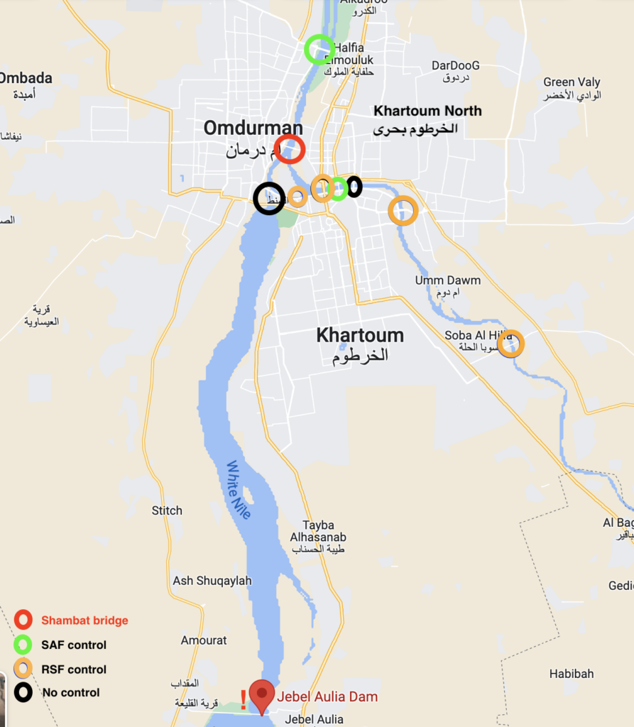
(RD / Google Maps)
(RD / Google Maps)
The importance of control
The problem for the RSF, now that the Shambat Bridge has been destroyed, is that they control not a single bridge that connects either Khartoum or Khartoum North to Omdurman in the west.
The Halfaya Bridge is controlled by the SAF and the White Nile Bridge and El Fitihab Bridge (officially the Victory Bridge) are both out of use as the army controls the Omdurman riverbank on one side of the bridge and the RSF control the Khartoum riverbank on the other.
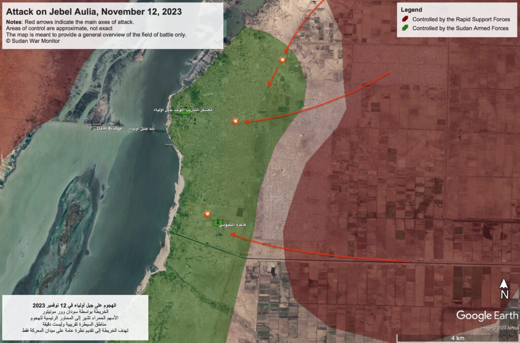
As a result, fighting has intensified around the Jebel Aulia Dam, roughly 40km south of Khartoum, in the past days. If the RSF manage to gain control over this dam, they have secured a supply line across the White Nile.
But why is this so important? The map from the Sudan War Monitor below shows that the RSF (yellow) control much of western Sudan whilst the army (red) controls much of eastern Sudan.
The RSF has its strongholds in Darfur, where its tribal roots lie, and in Kordofan and reportedly they get much of their supplies from these regions or via Chad and the Central African Republic. If they want to gain full control over Khartoum, or even remain in control of the neighbourhoods they currently hold, they need to be able to supply their troops from the west.
Similarly, if they would like to reinforce troops elsewhere, they need routes.
Jebel Aulia
Why try and take over a dam when there are other bridges in Khartoum? The Halfaya Bridge, north of the Shambat Bridge, is under army control and situated in close proximity to the Karari Army and Air Base in Omdurman so this bridge is of vital importance to the SAF and will be hard to take for the RSF.
The White Nile and El Fitihab bridges, too, have a Omdurman military site located across the water, where the SAF Engineers Corps has its base. Taking over such SAF strongholds would require supplies.
At the moment, the RSF in Khartoum and further east are isolated and the RSF troops in Omdurman are cut off from their colleagues in Khartoum.
Another interesting fact is that the Jebel Aulia Damn cannot be destroyed without flooding Khartoum, unlike normal bridges.
Jebel Aulia has been an army stronghold for the past months, as the map from October shows, and is also home to a military base but the RSF have managed to increase their presence in the area in recent weeks.
El Najoumi military base in Jebel Aulia is also not a fully equipped base but a heliport and has reportedly been raided by the RSF on the first day of the war, possibly disabling much of the equipment.
Two days ago, the RSF claimed to have already taken over the base although the SAF denies losing it. Sudan War Monitor also reported the takeover.
Heavy fighting has been reported in Jebel Aulia since Saturday and frightened civilians are fleeing the area en masse.
Nevertheless, the army is still in control of parts of Jebel Aulia and the east side of the dam and has a military training base there.
The fighting will likely concentrate on this area in the next days.
Outcomes
The future of the war depends to a great extent on these battles. If the army manages to prevent the RSF from gaining a passage to the west of the Nile rivers, that will change the power dynamics in the next weeks.
It would have a big psychological impact on the RSF troops in Khartoum if they are cut off from their strongholds in the West. Both Darfur and Kordofan important for the identity of the RSF because of tribal alliances.
With their vast economic network as well, the west of Sudan counts as the RSF’s political and economic heart.
If the RSF in Khartoum is denied any contact with the west and thus deprived of supply lines, it could also lead to a de facto split in the country between east and west. El Fasher and EL Obeid are the last cities in Darfur and Kordofan under SAF control.
If the RSF cannot maintain any strongholds east of the Nile rivers, and the army none west of the rivers, then that could result in a long-term division, a stalemate.
This would be a nightmare for many Sudanese people because it would split the country in half.
‘The future of the war depends to a great extent on these battles’
The control of bridges could also result in a nightmare for people living in other regions as fighting could spread further. If the RSF are denied access to bridges on the White Nile and the Nile around Khartoum, they could launch offensives in Kosti and other cities further south alongside the White Nile to secure bridges and communication lines there.
Towns in White Nile and Blue Nile state have been spared the worst of the violence in the past months and are places that many Sudanese have fled to.
The fight for the bridges is one to keep a close eye on.
* The RSF were established by the Al Bashir regime in August 2013 and grew out of the janjaweed militias which fought for the Sudanese government in Darfur since the war broke out in 2003. They were largely made up of Arab herding tribes. The janjaweed are held responsible for the genocide against Darfuri farmers and other non-Arab/African groups. The RSF are widely believed to be responsible for atrocities in the Kordofan and Darfur regions in the past years too and are also widely condemned for their role in the October 25 military coup and subsequent violence against pro-democracy protesters. Since the outbreak of war in April, the RSF has been accused of involvement in ethnic cleansing in Darfur and what has been labelled as the El Geneina Genocide.


 and then