


Yale HRL report: ‘11 more North Darfur villages razed by arson’
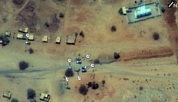
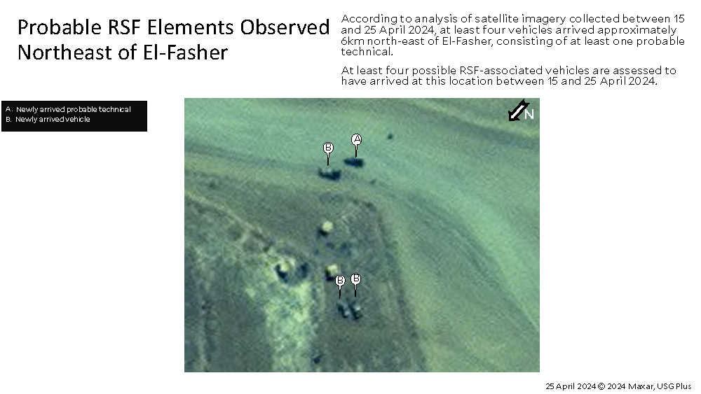
Satellite imagery dated April 24 showing 'probable RSF elements near El Fasher (Yale HRL / Naxar / USG-Plus)
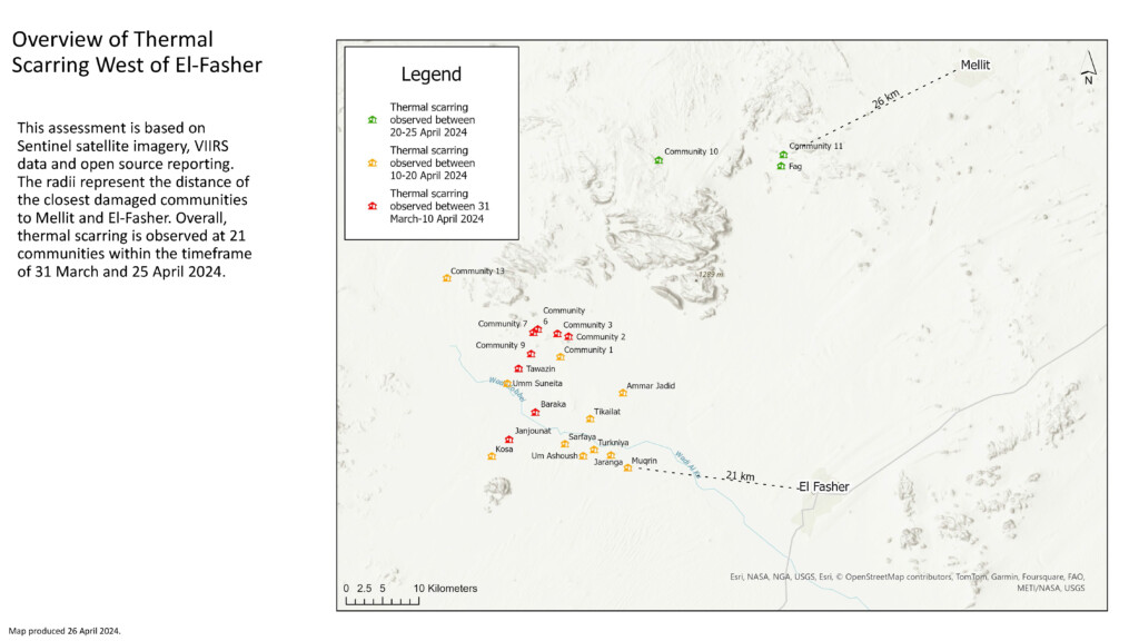
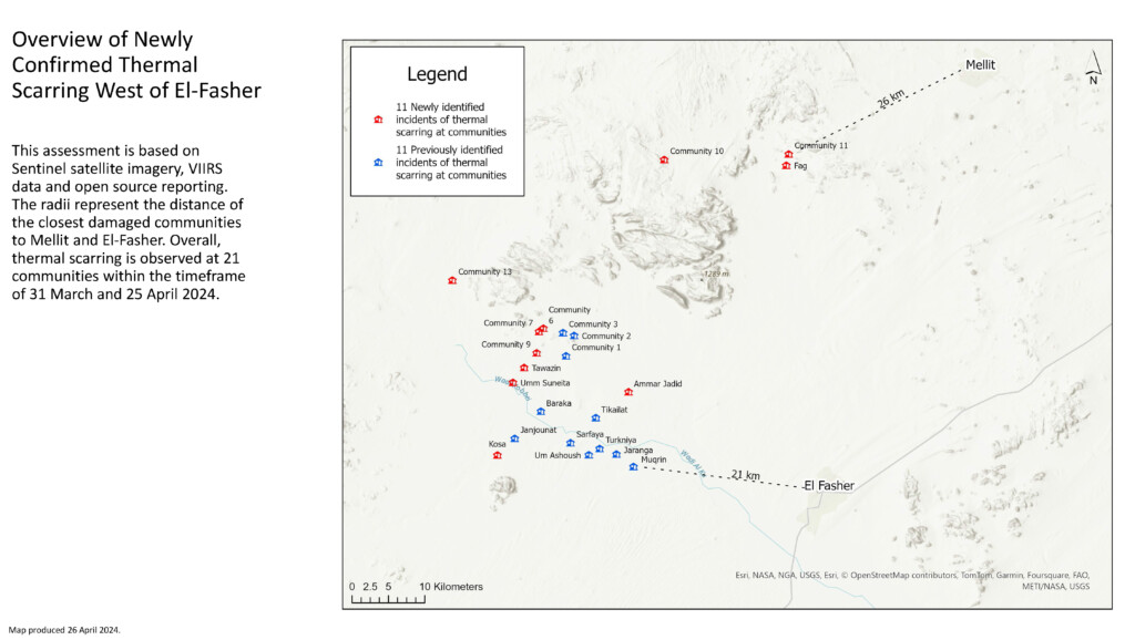
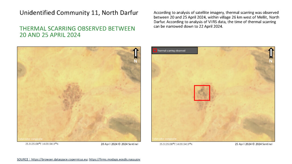
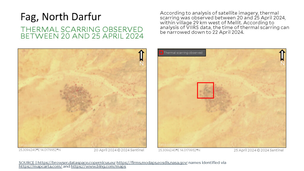
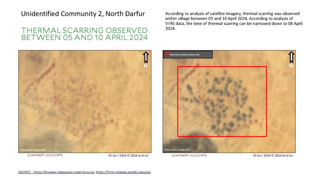
A new independent report confirms that an additional 11 communities in the area around El Fasher, capital of North Darfur, were razed by apparent arson between April 20-25. The report, based on analysis of remote sensing and open-source data, confirms the control of the paramilitary Rapid Support Forces (RSF) over the area, while the Sudanese Armed Forces (SAF) continue to bombard RSF positions to the east and north-east of the city. It infers “civilian mass casualties” from depravation and crossfire.
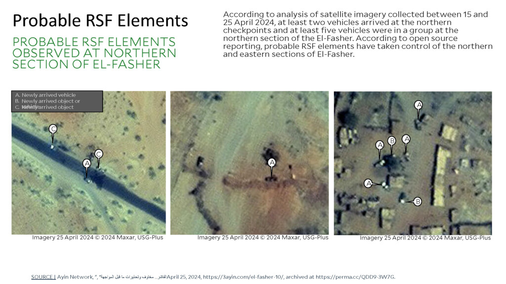
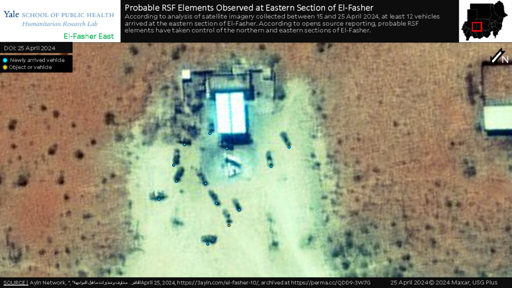
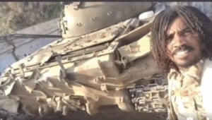
The key findings of the report published yesterday by the Yale School of Public Health’s Humanitarian Research Lab (Yale HRL) in the USA show visual confirmation via satellite imagery, showing thermal scarring at the locations of burned villages. The report, which also cites news coverage by Radio Dabanga, also confirms the presence in the area of “probable RSF elements”.
In related separate coverage by Radio Dabanga earlier today, Toby Harward, Deputy UN Humanitarian Coordinator for Sudan, warns that “the humanitarian situation in North Darfur and surrounding areas is dire.”
He adds: “The situation in El Fasher is precarious. The city shelters a significant civilian population, including displaced individuals who fled conflict in Darfur. The risk of violence poses a severe threat to their safety and exacerbates the already dire humanitarian conditions. Any escalation could lead to widespread casualties, further destabilising the region, and inciting tribal conflicts.”
‘RSF confirmed present in El Fasher’
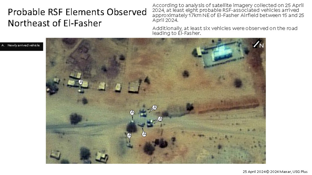
Yesterday’s Yale HRL report says: “The RSF are confirmed present in El Fasher, including likely checkpoints at major east and north ingress/egress roads in and out of the city,” , conforming that “an additional 11 communities razed by apparent arson: three of the communities are outside Mellit, north of El Fasher, between 20-25 April 2024, and an additional eight of the apparently burned communities are west of El Fasher and burned prior to 20 April 2024; and as of 18 April 2024, Sudan Armed Forces (SAF) bombardment of RSF on the eastern neighbourhoods and northeast access point of El Fasher was continuing.”
Yale HRL has visually identified “forces consistent with the RSF” in eastern and northern El Fasher. “Checkpoints controlling the major roads in and out of El Fasher are observed in satellite imagery from 25 April 2024. There is widespread open source reporting that RSF controls the checkpoints on the road heading north and east to Mellit, likely the Kutum Street connecting to the B26 road.”
Additionally, Yale HRL has visually identified forces consistent with RSF in the north of El Fasher apparently on the move on 25 April 2024. The report says that while Yale HRL has not yet visually confirmed reports of RSF movement from the south, the researchers are continuing to monitor the area, adding that “the SAF appear to be hardening positions to the west consistent with an expectation of RSF forces attempting to move from that direction as well.”
(File photo: Dan Ranzetti / Yale University)
Civilian casualties
Yale HRL confirms that the humanitarian situation has worsened, and while no targeted mass atrocities against civilians have been identified to date, “deprivation-related deaths from lack of basic necessities (food, water, medical assistance), [are] already occurring and widespread,” as are “civilian deaths from crossfire between armed actors”.
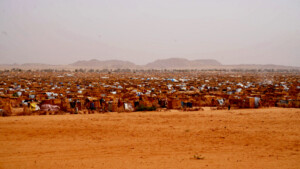
‘Under-resourced camps for displaced people are struggling to cope…’
Under-resourced camps for displaced people are reportedly struggling to accommodate increasing arrivals, including up to more than 50,000 people forcibly displaced from communities that the RSF razed to the west of El Fasher. Hospitals lack medical supplies and ambulances, the city has few working water locations, and water bottles and food are being further rationed.
Yale HRL says that there are reports of sexual and gender-based violence (SGBV) including sexual exploitation, sexual assault, and rape in shelters for displaced people, and “insufficient care for survivors has reportedly contributed to suicides”.
The attacks on communities west of El Fasher and near Mellit likely caused additional civilian displacement; “although Yale HRL cannot, at present, identify the status of the now displaced community members”.
Combat operations
HRL acknowledges that the current status of combat operations in El Fasher is not known, however the report has ascertained that the RSF has taken control of the northern and eastern routes into El Fasher through the capture of Mellit and positions on the eastern B26 road. “RSF forces in Nyala, Zalengei, El Daein, and other Darfuri areas are also reportedly in or moving to El Fasher to prepare for a rumoured minimum three front attack on the city.”
‘Both RSF and SAF have deployed artillery and heavy munitions without sufficient protection of civilians…’
Using satellite imagery, Yale HRL assesses that SAF and aligned forces are mobilising and continuing to harden defensive positions in and around El Fasher in anticipation of a large-scale urban assault.
Yale HRL says it has “has withheld information on these positions due to the potential for this information being used for targeting”, warning that “a large-scale RSF multidirectional siege and battle for El Fasher would have severe consequences for civilians in El Fasher.
“SAF is deploying airstrikes in an indiscriminatory manner, and both RSF and SAF have deployed artillery and heavy munitions without sufficient protection of civilians,” the report says, pointing out that “the RSF typically infiltrates neighbourhoods in waves and conducts widespread and targeted mass atrocities including mass executions, often of Masalit, Fur, and Zaghawa men and boys, sexual and gender-based violence toward women and girls, and systematically razing communities”.
 and then