


Nile foods across 5 Sudan states – opinions mixed on Grand Ethiopian Rennaissance Dam impact
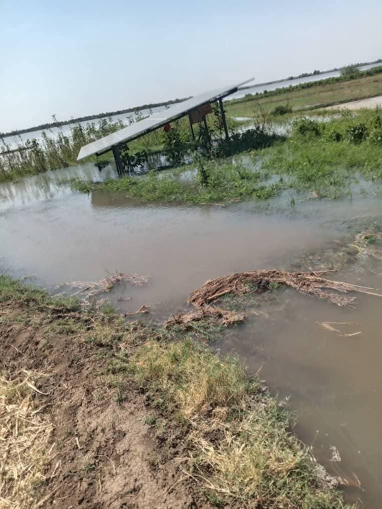
Flooding in Nawa District, Northern State - September 2025 - Supplied via Social Media
Today, the Nile floods swept away homes, residential neighborhoods, and agricultural lands in the Blue Nile region and the states of Sennar, Gezira, Khartoum, River Nile, and Northern.
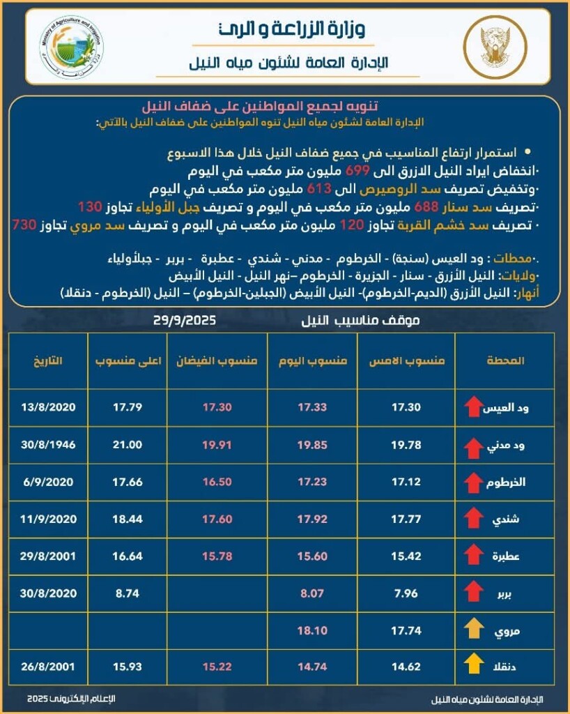
The General Administration of Nile Water Affairs, affiliated with the Ministry of Agriculture and Irrigation, issued a notice to citizens along the Nile’s banks to take the necessary measures to protect their property and lives, noting that water levels will continue to rise along all banks of the Nile throughout this week.
The administration warned of a drop in Blue Nile flow to 699 million cubic meters per day, a reduction in Roseires Dam discharge to 613 million, while Sennar Dam discharge reached 688 million cubic meters per day, and Jebel Awliya discharge exceeded 130 million. Discharge from Khashm El Girba Dam exceeded 120 million cubic meters per day, while Merowe Dam discharge exceeded 730 million.
They pointed out that the stations, states and rivers that reached flood levels are: Wad El Eis (Singa), Khartoum, Madani, Shendi, Atbara, Berber, and Jebel Awliya. The states are Blue Nile, Sennar, El Gezira, Khartoum, the Nile River, and the White Nile. The rivers are: Blue Nile (Ed Dein – Khartoum), White Nile (El Gebelain – Khartoum), and the Nile (Khartoum – Dongola).
‘GERD has nothing to do with the floods’
In an interview with Radio Dabanga, Engineer Abu Bakr Mustafa, a dam and infrastructure consultant, believes that heavy rains resulting from climate change are the cause of the floods, denying any connection between the Grand Ethiopian Renaissance Dam (GERD). He said that the heavy rains the country has been experiencing since last year are a direct result of the El Niño phenomenon and rising ocean temperatures, which have increased evaporation rates and disrupted the tropical depression, causing it to move northward to Aswan in Egypt.
He added that rainfall this year exceeded 150 mm per day in some areas, leading to torrential floods that swept through Kassala, Port Sudan, Dongola, Wadi Halfa, Atbara, Shendi, and even Khartoum and Omdurman. The Atbara River also recorded flows of 550 million cubic meters in August, more than double its usual rate. The Blue Nile was at its peak, but the filling of the Grand Ethiopian Renaissance Dam prevented a further catastrophe. Engineer Abu Bakr pointed out that the Grand Ethiopian Renaissance Dam (GERD) was closed in August, with only limited discharge from the turbines. This closure, he said, saved Sudan from a potential disaster, as flows could have exceeded one billion cubic meters per day if the Atbara floods combined with the GERD discharge. He added that the lack of coordination between Ethiopia and Sudan, and the reliance on outdated standards for dam management, exacerbated the crisis.
Lack of planning
The expert criticized the lack of urban planning and protection of the Nile banks, noting that population encroachment on river and flood channels contributed to the worsening losses. He also pointed to Sudan’s poor use of modern technologies such as internationally available satellites and radars, and its reliance on outdated protocols that assumed peak rainfall would end in mid-September, while facts have shown that the rains continued to be heavy until the end of the month.
Engineer Abu Bakr stressed the need to update monitoring and early warning systems, develop clear maps of flood paths, and halt uncontrolled expansion near the Nile. He also called for activating regional cooperation between Sudan, Ethiopia, and Egypt to manage the Nile’s waters to serve the peoples of the region.
Water levels expected to decline
In contrast, Dr. Abbas Sharaky, a professor of geology and water resources at Cairo University, told the Associated Press (AP) on Monday that water levels are expected to decline during the current week.
Earlier this month, Ethiopia inaugurated the Grand Ethiopian Renaissance Dam, the largest dam in Africa, to boost its economy. The dam, located on the Blue Nile near the border with Sudan, cost approximately $5 billion. Officials reported that it will produce more than 5,000 megawatts and is expected to double Ethiopia’s electricity generation capacity.
However, some have accused the dam of causing the current floods in Sudan. Sharaqi told AP, “The current situation is the result of human error.” He added that Sudan benefits from the flow of water from the dam during the agricultural season, but “the current situation is causing more harm than good, given that the harvest season is almost over.”
Sharaki pointed out that the Grand Ethiopian Renaissance Dam (GERD) was not being drained gradually, but rather stored water during Ethiopia’s rainy season between June and August, placing an additional burden on the dam. He added that the four turbines that were supposed to help reduce the water in the reservoir failed to operate, preventing Ethiopia from releasing the excess water, which flowed in massive quantities toward Sudan this week.
Urgent appeal from Jebel Awliya
The Jebel Awliya Emergency Room issued an urgent appeal, stating that the areas along the banks of the White Nile in Jebel Awliya locality are facing a real danger due to the rising water levels, which have swept through all the barriers on the banks of the Nile in several areas, including: “El Assal – Taiba El Hasnab – El Shaqilab – El Kalaklat”, and have been submerged by the rising Nile waters, making their way to residential neighborhoods and citizens’ homes, which are now threatened with collapse on their residents.
The Chamber confirmed that water levels are steadily rising, and that many areas are now threatened with complete submergence.
Damage in southern El Gezira
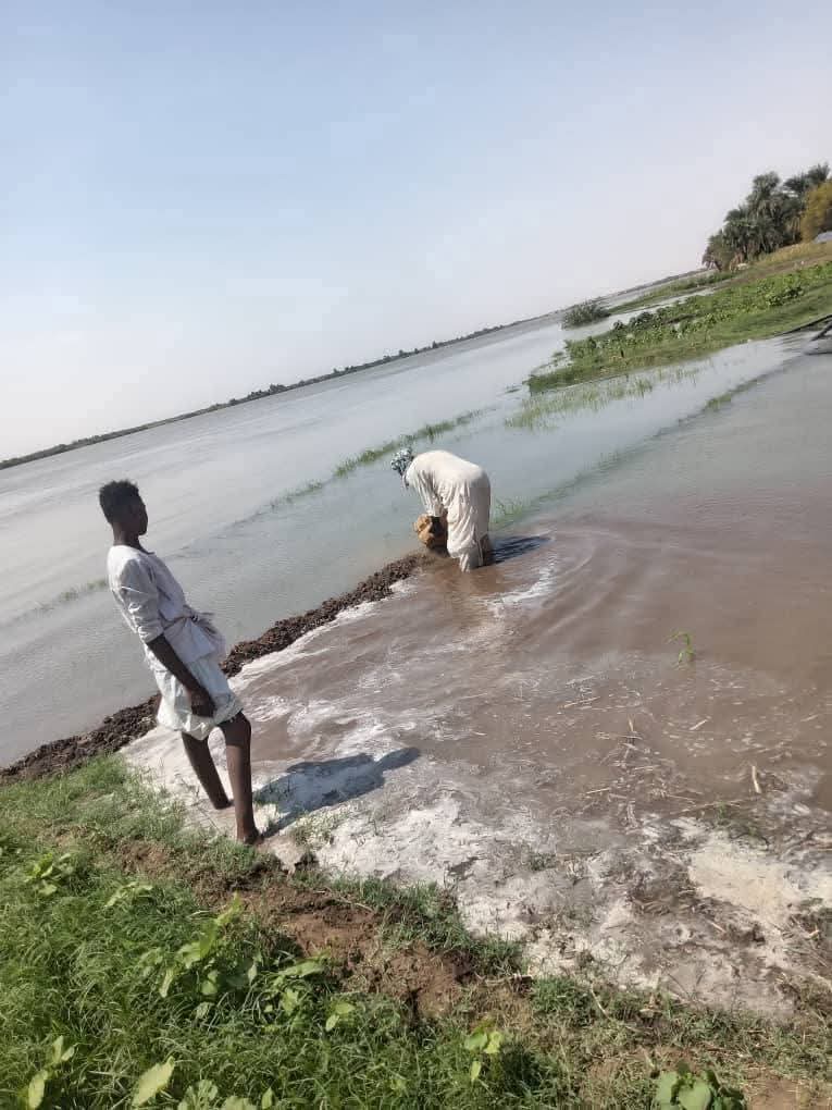
For his part, Mubarak Abdel Rahman Yaqoub, Director of Agriculture at the Wad El Haddad Administrative Unit in Gezira State, revealed that 1,764 acres of land, distributed across 176 farms in the Qandal area, benefiting more than 238 farmers, were damaged by the Blue Nile flooding in the areas of Daim El Mashaikha, Umm Dalka and Qandal in South Gezira Locality. The flooding, which occurred in the area of South Gezira, damaged 1,764 acres of land distributed across 176 farms in the Qandal area, benefiting more than 238 farmers, producing vegetables and horticultural products such as leafy greens, mangoes, citrus fruits and bananas.
The governor of El Gezira emphasized the importance of these areas in promoting horticultural exports and achieving food security. He stated that climate change contributed to the flooding, announcing support and compensation for affected farmers.
In River Nile State, water levels rose sharply in the Hajar al-Asal area in northern Sudan. This morning, torrential floods hit the village of Nawa, north of Dongola, swept through residential neighbourhoods and caused direct damage to homes and infrastructure.
Eyewitnesses confirmed that some houses partially collapsed, while large areas of agricultural land were submerged. The flooding also cut off the national road linking Nawa and Dongola at kilometres 32 and 34 after torrents swept away sections of the asphalt, paralyzing traffic and isolating several villages from the state capital.
Floods also inundated parts of Badin Island in the North and areas in Merowe, in addition to threatening Tuti Island.
In Sennar State, the Blue Nile floodwaters swept through Al Rayat village in Singa locality and the surrounding areas.
In the Blue Nile, large agricultural areas were damaged near the cities of Qaisan and Ad-Damazin.
Efforts to avoid flooding
For its part, the Sennar Dam Administration reported that it had made significant efforts to prevent flooding. Reservoir Director Engineer Mohamed El-Haj Mohamed Sand said that the administration dealt with the large quantities of water following increases observed in the upper reservoirs of the Blue Nile, noting that the lake was partially drained to avoid damaging the low-lying areas behind it.
Sand referred to warning bulletins issued by the General Administration of Nile Water Affairs at the Ministry of Irrigation regarding these increases, noting that in previous years, inflows were concentrated in the second half of August through the first week of September.
He stressed that the operation of the Grand Ethiopian Renaissance Dam has created a new water crisis, noting the lack of sufficient information about it, as the water was processed through measuring stations after it entered Sudan. He urged citizens living near the Nile, in low-lying areas, and in fragile areas to exercise caution, reassuring them that this increase would not last more than three days, after which the water would return to normal levels.


 and then