





Sudan war: Yale report reveals El Fasher’s devastation a year after RSF takeover
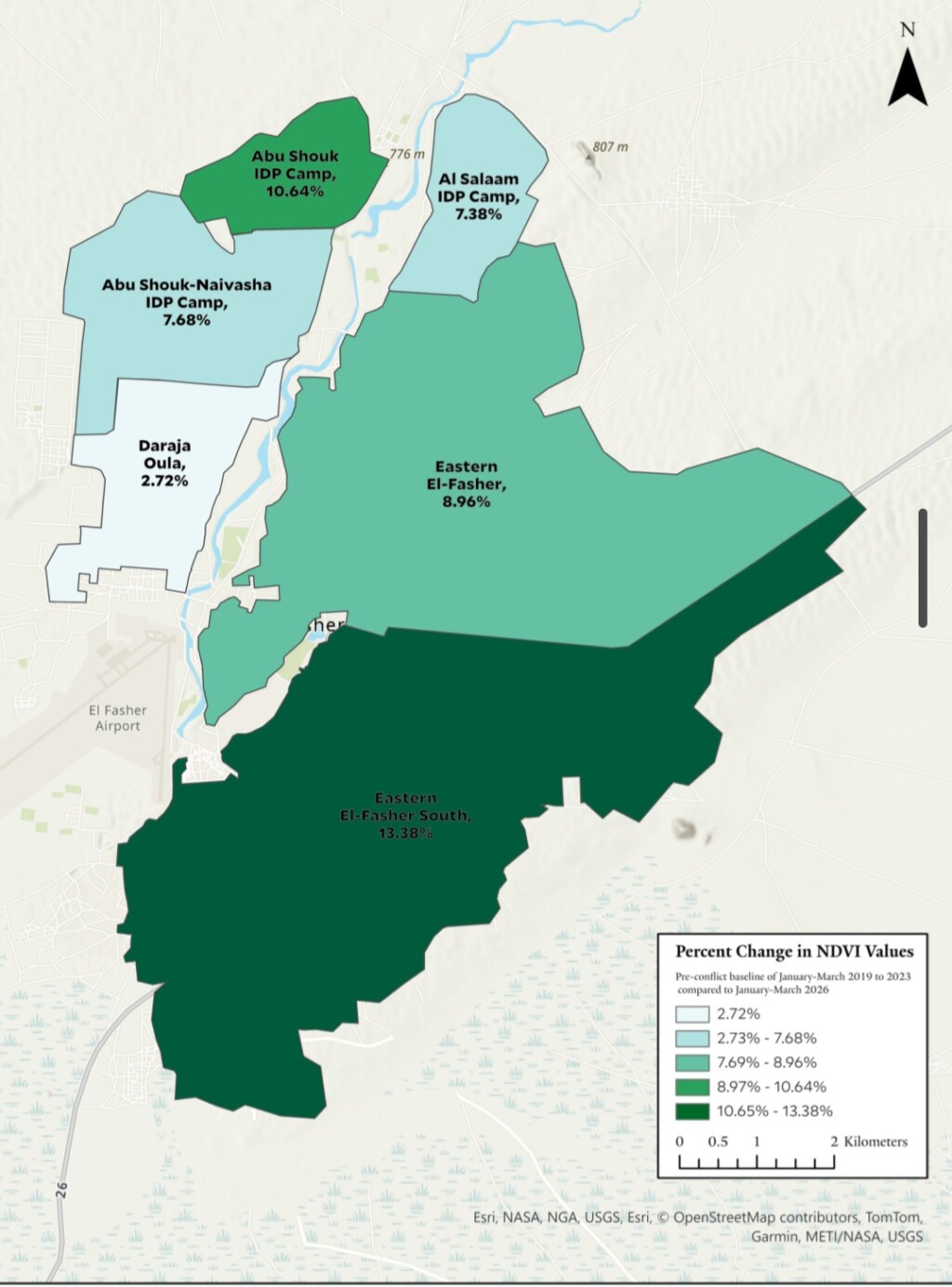
Map showing increased vegetation cover in El Fasher one year after Rapid Support Forces takeover (Image: Humanities Research Laboratory at the Yale School of Public Health(
Satellite imagery analysed by Yale University’s Humanitarian Research Lab shows a near-total absence of civilian life in the North Darfur capital El Fasher, with activity largely confined to an area of just five square kilometres. The report documents widespread damage to markets and hospitals, restrictions on civilian movement, and evidence consistent with the destruction or concealment of human remains.
El Fasher has been transformed into a largely deserted city, with almost no civilian presence beyond a small area of about five square kilometres, according to a new report by the Humanitarian Research Lab at Yale University’s School of Public Health.
Published to mark the first anniversary of the events in El Fasher, the report says the city and its surrounding displacement camps, including Abu Shouk, El Salam, and Zamzam, were home to an estimated one to two million people before the siege began in April 2024.
The siege lasted about 20 months. It was followed by widespread bombardment, starvation, and mass killings after the Rapid Support Forces (RSF) captured the city in late October 2025, leaving it almost entirely emptied of its original residents and displaced people, the report says.
Satellite imagery reveals environmental changes
Researchers used the Normalised Difference Vegetation Index (NDVI), based on Copernicus Sentinel-2 satellite imagery, to measure environmental changes between 1 January and 31 March 2026 and compare them with the average for the five pre-war years, 2019–2023.
The method relies on the observation that human and animal activity, as well as vehicle movements, limits vegetation growth in populated areas. The analysis found an overall 9.02% increase in vegetation growth within the city, which the researchers interpret as evidence of the cessation of daily activity and the disappearance of much of its social and civilian life.
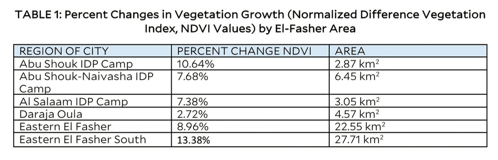
South-eastern El Fasher recorded the largest increase in vegetation growth, at 13.38%, followed by the area north of Abu Shouk camp, at 10.64%. The First Degree neighbourhood recorded the smallest change, at 2.72%, and remains the main area where RSF activity and the city’s residual population are concentrated.
Eight of nine major markets show no activity
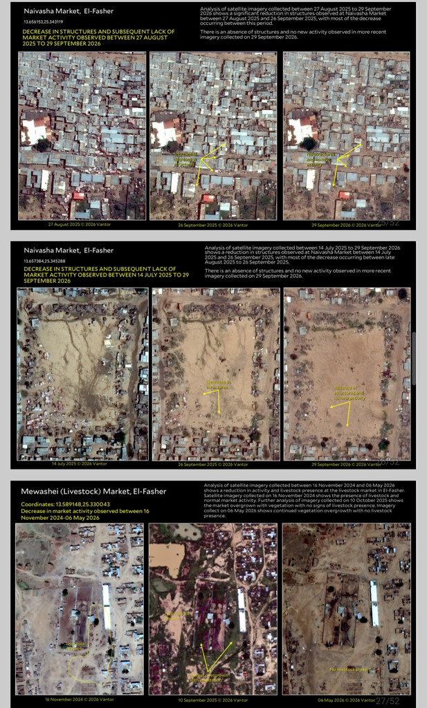
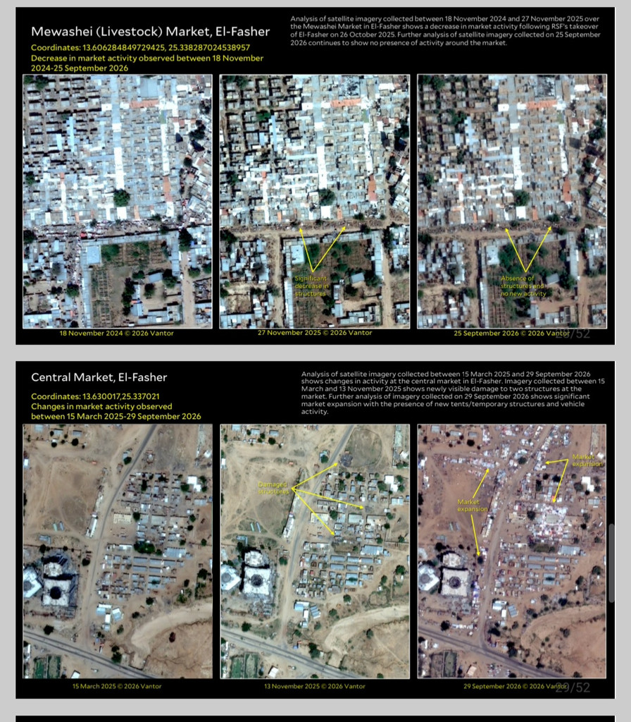
The researchers assessed nine major markets by comparing satellite images from September 2026 with a baseline recorded before the siege, in November 2023.
The images showed no discernible human activity, vehicle movements, or animal presence in eight of the nine markets, including the Grand Market, the livestock market, Um Dafsu market, and Nyfasha market. Many market structures had also been damaged or destroyed, with collapsed roofs and extensive vegetation covering the sites.
The central market in the First Degree neighbourhood was the only one showing visible expansion and activity, including new tents and shelters and vehicle movements. The report identifies it as the operational centre for RSF forces and the remaining civilians within the approximately 5 sq km area where activity persists.
Hospital imagery raises concerns over human remains
The report tracked 19 healthcare facilities across El Fasher. Satellite images showed no signs of crowds, organised ambulance movements, maintenance, or reconstruction at any of them.
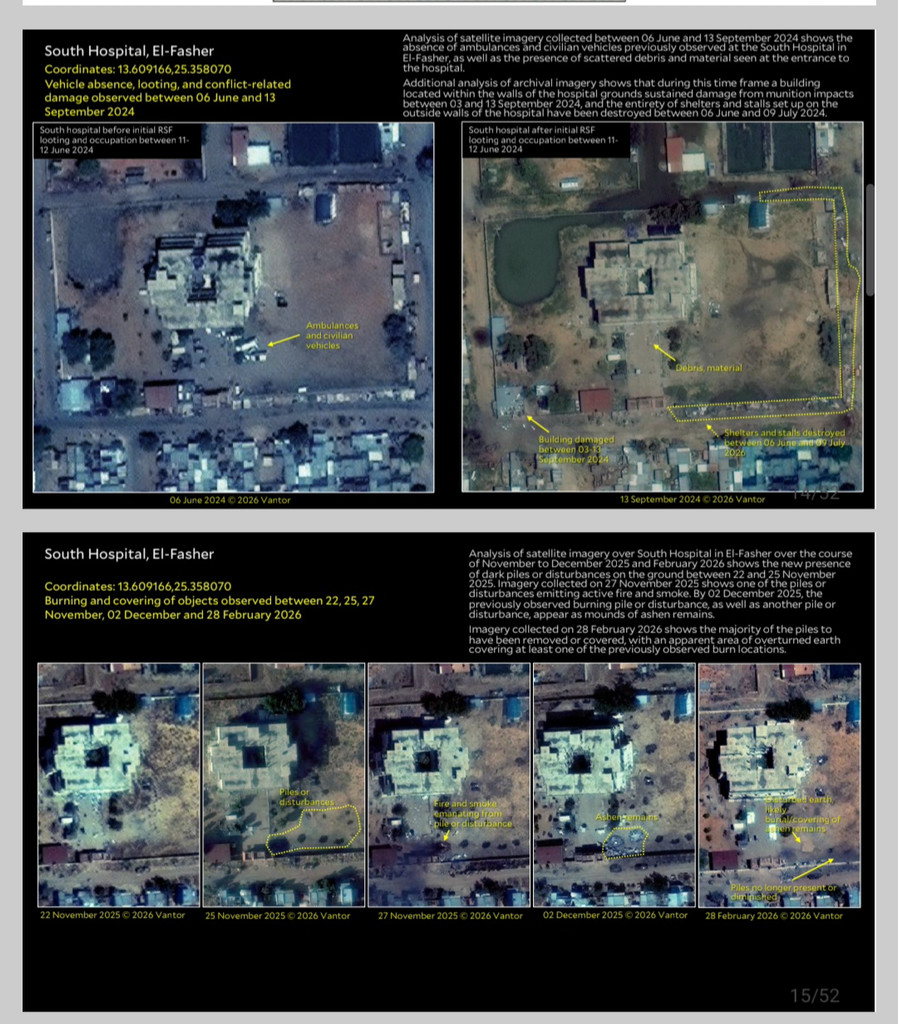
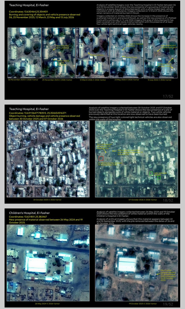
Researchers also identified excavation and burning sites at five major hospitals: the children’s hospital, El Fasher Teaching Hospital, the Saudi Hospital, Sayyid al-Shuhada Centre, and the Southern Hospital. The report says imagery indicated that materials consistent with human remains had been burned at several of these sites.
At El Fasher Teaching Hospital, satellite images taken between November 2025 and March 2026 showed a newly dug pit containing ash. Scattered materials and a flatbed truck were visible in May 2026. By July, the pit had been completely covered with earth, and armed four-wheel-drive vehicles were present.
At the children’s hospital and the Southern Hospital, the report documented ground disturbance and soil changes that could indicate the use of mass graves or the burial of evidence from burning sites. In September 2026, researchers identified a new pit outside the children’s hospital compound that was subsequently filled in.
The report also cites local and media accounts alleging that RSF forces moved bodies and human remains from killing sites and exhumed temporary graves to transfer remains to designated burial sites out of public view, potentially concealing evidence.
A 75km earth barrier restricts movement
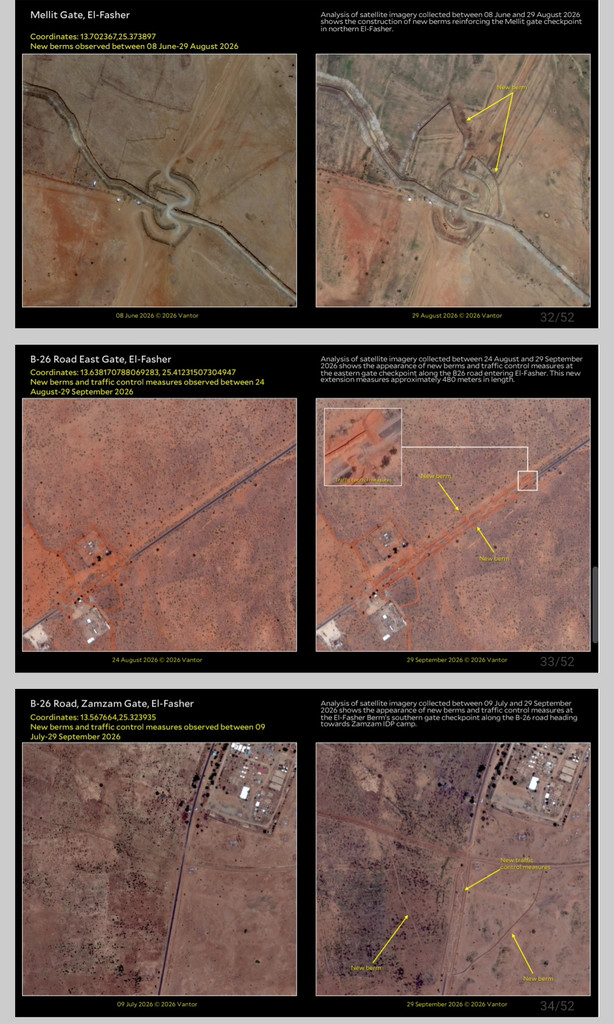
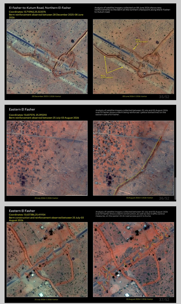
The report documents the construction and development of a trench and earth embankment extending for 75km around the city. It says the barrier was designed to restrict civilians leaving El Fasher and humanitarian aid entering it.
The RSF reinforced the four remaining main crossing points with earth barriers and complex traffic routes intended to impede movement. These included the Mellit Gate crossing to the north and the B-26 road crossing to the east and south, towards Zamzam camp.
Some exits were completely closed, the report says, preventing large-scale civilian flight and tightening the siege. The resulting restrictions contributed to worsening famine conditions, classified as Integrated Food Security Phase Classification (IPC) Phase 5.
Water infrastructure damaged
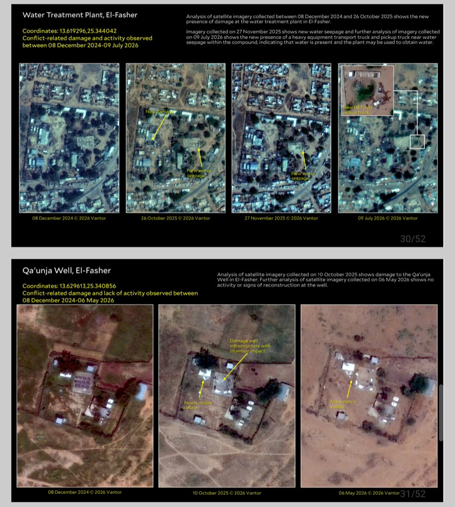
Satellite imagery showed damage to the main water station caused by bombardment, alongside signs of water leakage and the presence of heavy transport trucks and armed RSF vehicles. The report says these developments indicated attempts to control the city’s sole water source.
Images also showed that Qaounja well had been hit by missiles, with maintenance or operational work halted until May 2026.
Yale report calls for international investigation
The report concludes that official claims by the RSF and affiliated administrations that life has returned to normal in El Fasher are contradicted by satellite-based evidence.
It says the city has been the scene of possible war crimes and crimes against humanity, as well as acts bearing “the hallmarks of genocide”, citing the characterisation used by international UN investigators.
The researchers call for an international investigation and unrestricted access for the International Criminal Court and human rights organisations to collect remaining evidence before it is destroyed.
The report also criticises the international community, arguing that the catastrophe in El Fasher was among the most anticipated humanitarian disasters, with early warnings issued over more than two years. Political interests and diplomatic calculations, it says, prevented decisive action to protect civilians.



 and then